Granite State Crossings

Hunter Research recently completed a multi-year project working closely with the New Hampshire Department of Transportation (NHDOT) to update the state’s historic bridge inventory and create a new statewide historic bridge management plan. During the 1980s, New Hampshire was among the first states in the nation to complete a historic bridge inventory per requirements of federal law. By the early 2010s, however, the original inventory had become obsolete and had not been comprehensively updated in more than three decades.

Hunter Research worked closely with specialists from NHDOT’s Bureau of Environment and the Bureau of Bridge Design to digitize existing historical data and have Hunter Research’s architectural historians review and make updated eligibility assessments for all NHDOT-inspected state-owned, town-owned and rail-over-highway bridges over 10-foot span built prior to 1978 (over 2,600 bridges). Eligibility recommendations were grounded in a new statewide historic bridge context statement and discussion of application of the National Register Criteria for Evaluation (A, B, C and D). The prior inventory had been mostly focused on Criterion C for engineering and architecture. The updated inventory paid particular attention to Criterion A for associations with locally significant patterns of historic transportation development and cultural landscapes.

Hunter Research coordinated with NHDOT’s Department of Information Technology to integrate a historic bridge layer, with all of the findings and supporting documentation for individual bridges, into a GIS application accessible to NHDOT staff. This data will be ultimately exportable to the NH Division of Historical Resource’s (NHDHR’s) cultural resources GIS and available to the public. This data is now being used by NHDOT and NHDHR to streamline Section 106 reviews and facilitate project planning and coordination for bridges identified as eligible for the National Register of Historic Places. Non-historic bridges are being cleared more efficiently.

The statewide historic bridge management plan offers NHDOT-approved menus of alternatives to consider when developing projects to preserve or rehabilitate historic bridges, based on bridge material and type. Options are also provided for minimizing or mitigating adverse effects when they occur, facilitating the development of Memoranda of Agreement (MOAs) when needed. The plan was developed over several years of meeting with senior staff from the Federal Highway Administration (FHWA), NHDOT and NHDHR.  Patrick Harshbarger of Hunter Research served as project manager and the chief technical expert on historic bridge best practices.

Potteries of Trenton Society Makes Trenton's Industrial Ceramic History Available on the Web

A shout out to our friends at the Potteries of Trenton Society (POTS), who have been working to make information on Trenton’s industrial ceramic industry available on the internet.  POTS’ website (www.potteriesoftrentonsociety.org) has recently undergone a major overhaul and redesign with a view to making it more user friendly and technologically capable of hosting the Trenton Potteries Database.  This database contains historical information and stories about the pottery industry and associated history. Organized by geographic location, each entry includes information on a pottery's location, owners, products and years in operation. Where available, historic maps, advertisements, maker's marks, photographs and engravings are included in the database. 

On April 17, POTS, together with the Bard Graduate Center and the New Jersey State Museum, presented their annual ceramics history lecture. Dr. Laura Microulis, Research Curator at the Bard Graduate Center in New York City, discussed “Trenton’s Majolica Mania”. The lecture is available for viewing here.

The Randolph Friends Cemetery – Respecting a Final Resting Place

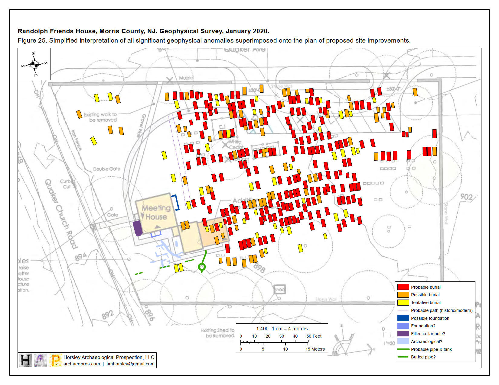
This winter Hunter Research completed an archaeological investigation at the Randolph Friends Meeting House Cemetery in Randolph, Morris County, paving the way for a new parking lot and pathway.  The extraordinarily well-preserved frame meeting house, built circa 1758, is New Jersey’s oldest extant colonial wood-frame Quaker meeting house and the oldest standing structure built as a house of worship in Morris County.  The Randolph Friends Meeting House & Cemetery Association have embarked upon a project to provide some much needed parking on the property within the bounds of the cemetery on the site of a former wagon shed.  Although no grave markers stood in this section of the cemetery, there remained a possibility that graves were present, as Quaker burials typically went unmarked up until the mid-19th century.

Archaeological investigation began with a ground-penetrating radar (GPR) survey conducted by Dr. Tim Horsley. This work identified over 70 anomalies interpreted as potential grave shafts within the limits of the proposed parking lot and associated pathway.  A grant was obtained from the Morris County Historic Preservation Trust Fund to support archaeological “ground truthing” of the geophysical findings. In January of 2021 a Hunter Research field crew, assisted by an excavation contractor who has worked with us for over 30 years, carefully opened up three large trenches within the parking lot and pathway footprints. After removing the topsoil and scraping off the surface of the underlying subsoil through a combination of machine and manual excavation, a total of 43 potential grave shafts were exposed as rectangular outlines with a different soil color, many of which correlated with the GPR anomalies identified by Dr. Horsley.

Identifying a grave shaft does not necessarily mean that anyone is “home,” so to speak.In an effort to determine the presence, depth and condition of human remains within these grave shafts, ten were selected for exploratory excavation.Of these, nine were confirmed to be grave shafts through the presence of human and/or coffin remains.Unfortunately, the survival of skeletal material was poor; most burials had less than 25% of the skeleton remaining, due largely to the slightly acidic soils.Despite this poor preservation, shroud pins and even burial shroud fragments were identified.Of the nine burials, five were judged to be those of children.The skeletal remains were not removed, but instead exposed, documented in place, and carefully reburied along with any associated grave goods. These investigations have provided useful insights into late 18th- and 19th-century Quaker burial practices while giving the Association the information they need to design their parking lot and pathway without impacting the cemetery’s residents lying in repose.