Archaeology

Hunter Research Identifies Foundation of 18th-century New Brunswick Church

Archaeological Monitoring at the 1st Dutch Reformed Church of New Brunswick 

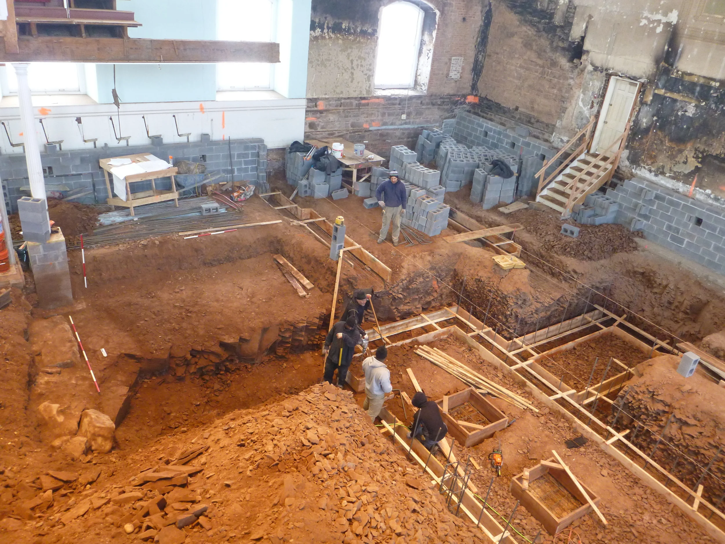
In 2013, as the Town Clock Community Development Corporation prepared to redesign the 1st Dutch Reformed Church of New Brunswick as a multifunctional community complex featuring supportive housing for victims of domestic abuse, site preparation work was accompanied by an exploratory archaeological investigation along the exterior of the west end of the existing circa 1811-1812 church.  From that initial work, an archaeological monitoring program was developed and begun in January 2014 to monitor the complex excavation taking place both along the exterior and interior of the State and National Historic Site Registered structure. We are excited to report that the truncated foundations for the previously unknown location of the circa 1767 church that once stood on the property have been identified within the existing church’s footprint. 

Interpreted east wall of the original 1767 church uncovered during excavation.

Interpreted east wall of the original 1767 church uncovered during excavation.

Excavations conducted on the interior of the 1812 church are conserving the historical integrity of the church's exterior.

Excavations conducted on the interior of the 1812 church are conserving the historical integrity of the church's exterior.

Data gathered from this monitoring program indicates the smaller earlier structure measured approximately 55 feet north to south by 50 feet east to west.  Evidence also suggests the south and west walls of the earlier church were reused in place and built-upon during the construction of the early 19th century church.  Several episodes of robbing from the earlier foundation would seem to indicate stone and other material were extracted and reused as the footprint of the standing church was expanded to the north and east.  Work remains ongoing at the site, with monitoring being conducted by Joshua Butchko

For more information, check out Dina's Dwellings by the Town Clock Community Development Corporation

Morris Canal, Lock 2 East, Wharton, NJ

The mystery object following its 2011 excavation.

The mystery object following its 2011 excavation.

Project Description

In Fall 2011, Hunter Research was retained by the Borough of Wharton, Morris County, New Jersey, to perform archaeological monitoring of the excavation of Morris Canal Lock 2 East under grants from the New Jersey Department of Transportation and the Morris County Preservation Trust.  The New Jersey Historic Preservation Office provided project oversight owing to the Morris Canal being listed in the New Jersey and National Registers of Historic Places.  Hunter Research had performed an archaeological excavation and survey of the lock and associated structures in 2006, establishing the integrity and extent of the subsurface remains.

Working closely with the contractor to maintain the project’s schedule, Hunter Research monitored the excavation of the approximately 100-foot long masonry and timber structure.  During the excavation Hunter Research encountered the remains of the wood and iron wicket gates for the upstream drop gate and the wood lock gates, which were carefully excavated and documented. The walls and floor of the lock, which show various stages of historic construction and repair, were also recorded.  Documentation consisted of in-field scale drawings, photography and recovery of the gates and associated hardware. These are among the most intact gates recovered from the canal in modern times and have led to many insights into their design and construction.

The Lock 2 East project attracted intense interest from the Canal Society of New Jersey, the Society for Industrial Archaeology and other members of New Jersey’s active community of canal history enthusiasts.

General Plan of Morris Canal Lock with Detail and Location of the Gudgeon.

General Plan of Morris Canal Lock with Detail and Location of the Gudgeon.

The Mystery Object: Gudgeon – Morris Canal Lock 2 East

This rare iron casting is a gudgeon from the wood mitre gates of Morris Canal Lock 2 East, the second lock east of the canal highest level. The gudgeon connected the gate’s timber heel post to a gate sweep, also known as a balance beam. The locktender pushed against the sweep to move the gates once the water levels on either side of the gate were equalized.


The Morris Canal cuts across the hills of northern New Jersey, overcoming a total elevation change of 1,674 feet from New York Harbor to the Delaware River, and historically was used to haul coal from the mines of northeastern Pennsylvania to the Port of New York. Construction began in 1825 and when completed in 1836 the canal comprised 23 inclined planes and 23 stone-lined locks that, by the time the canal was closed in 1924, were up to 100 feet long, 11 feet wide, and with a lift of 8 to 12 feet.

Historic view of Lock 2 East taken in 1904.

Historic view of Lock 2 East taken in 1904.

Communities in northern New Jersey are currently working to convert the former alignment into a greenway with restored features and interpretive exhibits. To learn more about the Morris Canal, visit www.canalsocietynj.org and www.morriscanal.org.